Venta Spur Bicycle/Pedestrian Bridge Ribbon Cutting

The City of Irvine has completed a bicycle - pedestrian bridge over the 133 toll road to connect the Great Park to Northwood. Please join us as the community celebrates with a ribbon cutting program. This new link will create a vehicle free connection across the 133 Toll Road between Trabuco/Great Park Blvd. and Irvine Blvd.

We would expect most BCI members to ride in on a bicycle...

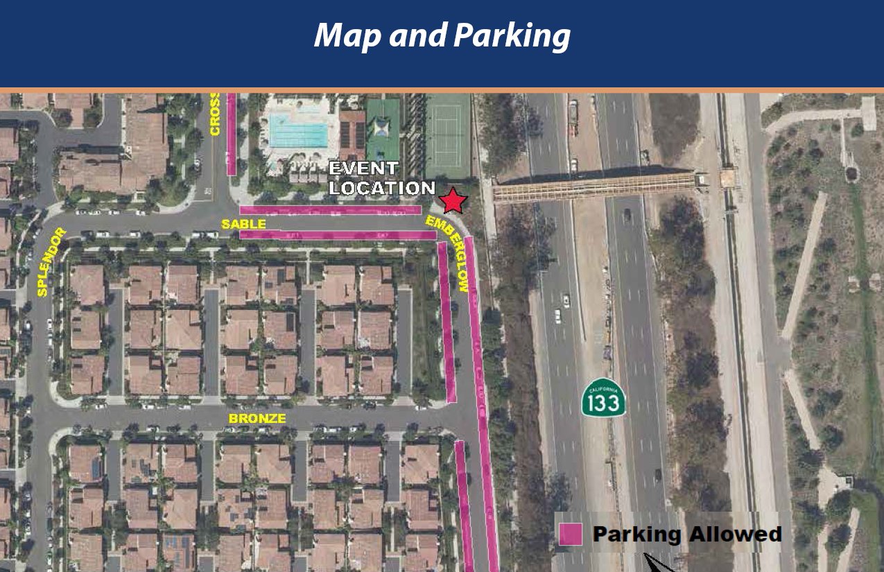
Location: Corner of Sable & Emberglow https://goo.gl/maps/bKbQxZsdfLAEYm988

Climb Factors

So on yesterday’s ride Rick asked Bill if there was a hilly-ness rating we might use to rank routes… intrigued, as “flat” “rolly” and “hilly” was always subject to the interpretation of the ride coordinator, and what Norm called “flat” was not what everyone else experienced as flat.
Now that RWGPS gives us a +/- elevation change on every route we design, we can calculate the factor of elevation divided by the miles of the ride to come up with a “feet per mile” number we’ll call the “Climb Factor”.
Bill ran the numbers on the Tuesday Routes and found a range from less than 20 feet per mile to over 50 feet per mile: Tues14 & 18 are less than 20’/m; (Climb Factor 1)
01 & 13 25 are in the 20’s. (Climb Factor 2)
Most routes are 30’/m to 40’/m. (Climb Factor 3 & 4)
06 & 17 30 are over 50’/m. (Climb Factor 5)

Our Weekend Routes range from CF 0 (less than 10 ft per mile on DCP01 S with 109 feet in 18.2 miles) to CF 7 (over 70 feet per mile on DCP21 L+ at 4,594 feet in 59.7 miles!)
So when a Climb Factor is on a route, it can give you an idea of how much elevation you can expect, relative to the distance. (Probably TMI but maybe it will catch on!)

Since most rides start & end at the same location, the climb and descent are the same. Some rides - like Riverside down stream to Anaheim may have a Climb Factor in a negative number.
You can do your own calculation: If the route is 38.3 miles & elevation is shown as +/- 1,234 ft just do the math: 1,234 / 38.3 = 32.2’/m (feet per mile) so that would be a “Climb Factor 3”

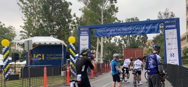
Team BCI and the UCI Anti-Cancer Challenge 2022

Thanks to you all for your support of BCI’s participation in UCI’s Anti-Cancer Challenge on October 8th 2022 !

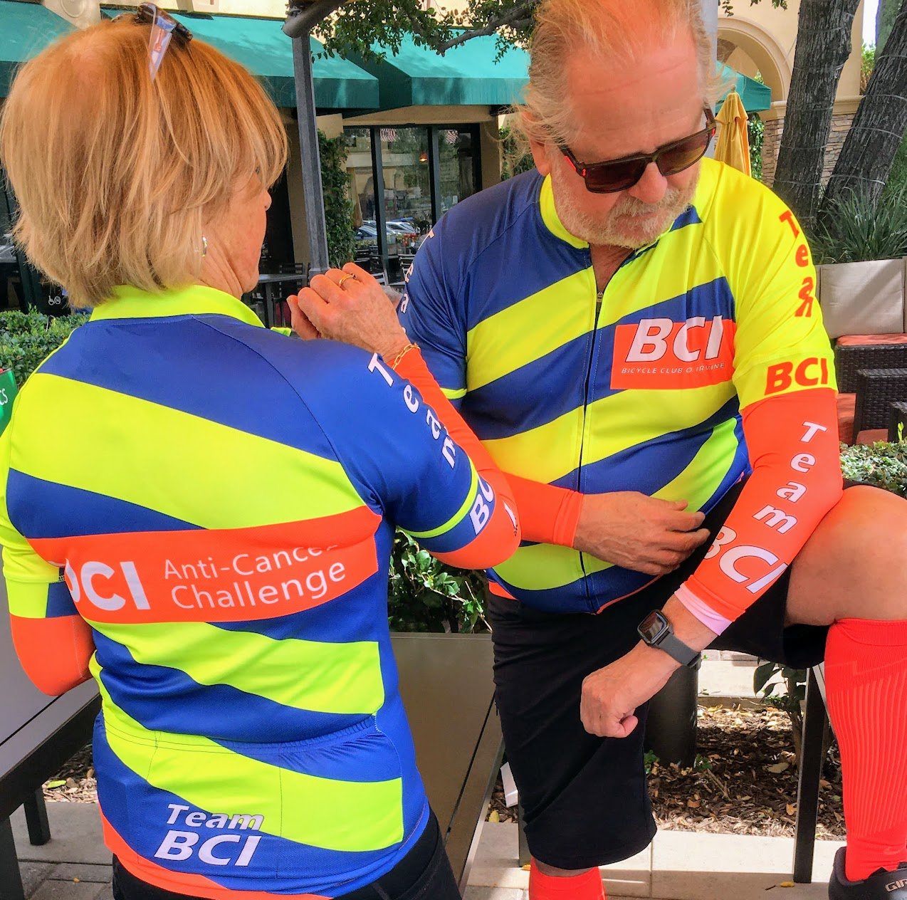
A special thanks to you, VP Dave Murphy, for your generosity in providing TEAM BCI’s jerseys!

For the first time, TEAM BCI exceeded its goal and raised $1,044 contributing to the nearly $1 million ($921,00 and still incoming) grand total. TEAM BCI also surpassed its greatest number of participants to date - 15!

Yesterday's culminating event was awesome! Amazing to be among such a diversity of participants ~ babies, families, friends, survivors ~ gathering, honoring, running, walking, riding with a common purpose, to end cancer.
The positivity and enthusiasm was inspiring!

Big KUDOS to you all.

Thank you, Deby Six

Daniel Stetson & Tony Abatjolou

Summer Weekend Ride Start Schedule Reversal

Given concerns of many members, a survey was conducted of member sto se ehow the membership felt about the weekend start time shift to 8am on July 2nd.

Over 60 members responded to the survey and the results were discussed at the board meeting to decide on if the schedule change should be reversed or amended.

The decisions were made to go back to 9:00 starts on Weekends, and to add an 8:30 start time for long rides on Sundays.
The rides have been adjusted and this weekend we will start at 9. As always, individuals are free to ride early or later and miss out on the group start, but we’ll see each other along the road and at the regroup points.

Here are the survey results, used to help inform the decision:

Annual Meeting / Elections Change Proposal

At the March 3rd Board Meeting, a motion passed to revise the BCI Bylaws to allow shifting the Annual Meeting away from January. The proposal is to hold our Annual Meeting on October 15th, rather than in January. The reasons include: we have had a hard time having an outdoor event if a Covid-19 spike occurs and have inclement weather. The busy holiday season is always a stressful time to pull together a ‘banquet’ dinner and gather members. The generous sponsors who traditionally provided raffle prizes are swamped with year end business and may be able to contribute more easily in any other time of year. The Annual recognition of Strava Riders and the Annual Member of the Year “Spirit Award” would still be recognized at the January General Membership Meeting.
The biggest impact would be stepping up the election of officers and seating of the Board. The current Board would be up for re-election or replacement in October and the next Board would be identified as the 2022-23 Board to serve until the Annual Meeting in 2023.
In order to do this, the Bylaws would need to be amended.
The amendment will be formally presented at the March 10th General Meeting and after 3 months of consideration, will be voted on by the membership at the June 9th General Meeting.
You can see the details of the proposed revised text, as well as our current and several prior Bylaws on this web site under the “INFO” tab.

Benevolence Committee

With such a large club we are like an extended family, and have care about each other. When members suffer a loss, challenge or injury, we sometimes don’t hear about it, but the outreach of a friend can really help uplift us in challenging times. Given the ‘new normal’ of endemic Covid-19 we gather less often and can easily miss hearing news.
Director @ Large Kathy Shapiro has stepped forward to chair a benevolence committee to help collect news and offer support. If you are interested in joining her ‘team’ please let her know.
We have set up a separate blog to allow comments & updates.

Full Board Seated

The 9 officers were formally elected in the run up to our Annual Meeting in January,
and at the February Board meeting 2 Directors at Large have been appointed
to complete the 11 member Board of Directors.
Paul Haussler has been followed by Marsha Murphy as Ride Coordinator
Jane Schrenzel has handed over her job to Kim Gerrard as Secretary
Dev Sellin and Marsha Murphy have been replaced
by Chris Norton and Kathy Shapiro as Directors @ Large

The other 7 incumbent officers were re-elected to continue their work.
The entire Board is listed here.

Please congratulate and thank the current and outgoing board members!

"News Alerts" delivery issues

We send out a “News Alert” email every couple of weeks to highlight upcoming events and announce news. Several members have not gotten them for various reasons. Most obvious is if you change your email address and don’t update your membership record. There may be a simple typo in your address. If you accidentally clicked our email as ‘junk’ it may remember that for future emails. Look in your junk/spam inbox. Less obvious; some mail servers like Yahoo & iCloud scrub our email as spam, as it is sent to over 300 members and may not have all the certifications the receiver’s server requires. It may help to add our address bci@mail.tidyhq.com to your address book, but not always.
Plan B: If you still are not getting News Alerts - you might want to create a free Google account & give BCI that gmail address. You can set up the gmail address to forward the BCI mail to your preferred ‘real’ address.
If you are added to our ‘Rejection Blacklist’ we can try to remove you.
Why do email addresses get put on this list?
The email bounced and cannot be delivered, or the recipient marked the email as spam.
If you are not getting the News Alerts,
1: Check if your membership has expired (only sent to current BCI members),
2: Check if we have your correct email address,
3: Contact us to see if you are on our Rejection Blacklist,
4: Add bci@mail.tidyhq.com to your “known senders” and/or add it to your address book / contact list.
We are not sure, but it may be that you CAN receive emails only sent to you - like renewal notices, but the News Alerts going to 300 people triggers a ‘spam’ concern on your end…
Let us know if you don’t get Alerts but do get renewal and membership updates.

2021 Strava Challenge Awards

At the Annual Meeting, the top 3 men and women across 4 categories were recognized by Statistician Ed Trainor. Miles recorded, Distance recorded, Rides recorded and Moving “Time in the saddle” have all been tracked and tabulated for the calendar year. 12 Certificates ‘suitable for framing’ were prepared and sent to recipients. Congratulations to all !

John Condia recorded an amazing 15,446 miles in 2021,
followed in 3rd & 4th by Mike Hollinden (9,983 miles), Bruce Campbell (9,615 miles)

Dori Lewis was 1st among women, and second over all with 10,041 miles,
Gloria Nafel recorded 6,175 miles for 2nd among women,
& Karen Cook recorded 5,019 miles for 3rd

Men: Top 3 Elevation:
John Condia (905,892 feet), Bruce Campbell (552, 425 feet), Joe Elwood (537,234)
Most Rides (Activities) recorded:
John Condia (378), Larry Fletcher (259), Vince Wilhelm (258)
Most Saddle Time:
John Condia (1036 hours), Mike Hollinden (757 hours), Richard Henley (756 hours)

Women: Top 3 Elevation:
Gloria Nafel (292,999 feet), Dori Lewis (278,360 feet), Virginia Frazer (177,733 feet)
Most Rides (Activities) recorded:
Dori Lewis (210), Gloria Nafel (202), Beverly Franks (144)
Most Saddle Time:
Dori Lewis (636 hours), Gloria Nafel (476 hours), Karen Cook (373 hours).

All of the final results are posted, and the 2022 Strava Challenge is already a month old but jump on ! More…

2021 Spirit Award recipient

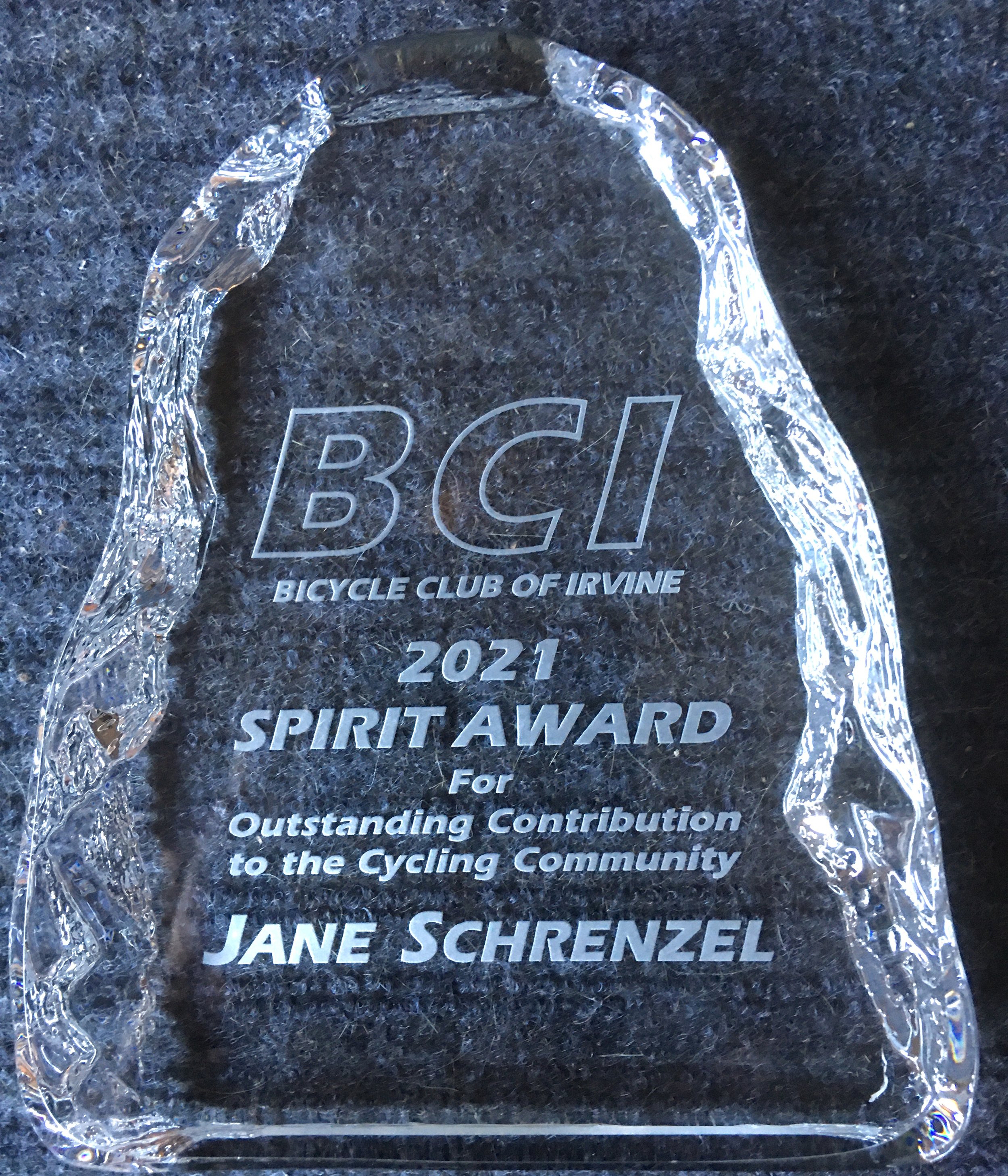
At our 2022 Annual Meeting, Jane Schrenzel, BCI# 3815, outgoing Secretary, was awarded our Member of the Year “Spirit Award by Membership Director Deby Six. Jane joined BCI in May of 2006 and has served in the past as our Director of Hospitality.
The engraved glass award was physically presented to her on Tuesday’s club ride ride by President Marc Urias.

Photo: Peter Gerrard

Route Slip Cue Glossary

BCI no longer prints route slips; riders need to print up your own route slips
(links to printable .pdf are available at each ride description)
Most were set up in the “before times” to be printed & cut in half; they have 2 slips per page, and all 3 routes in one 3 page .pdf file. Newer ones may be set up to fold in half, allowing larger fonts & readability.
Just print the page(s) you want, and fold (or cut in half to share with others if duplicates...)
Tuesdays have different 30 & 25 routes side by side on one page to fold.
Some remotes may or may not have the 2-per-page formats.

If you do not have a printer, get a friend to bring an extra copy for you.
Note - RideWithGPS does generate a cue sheet for each route,
but
the BCI Route Slip is most accurate and designed to fit on 1/2 page slip to clip to your handlebar… Print the BCI route slips!

Folks may be curious or wonder what the odd turns are that are listed on BCI’s
Route Slips / “Cue Sheets”. This glossary will translate those cryptic cues:

L, R & to are obvious (L = LEFT R = RIGHT to = Continue to / name change etc)
but here are some other cues you may see:

°L = CIRCLE LEFT - You are going most of the way around a ‘round-a-bout’ or traffic circle, effectively ending up going left around the circle 3/4 or 7/8 of the way. (See details about round-a-bouts below)

°R = CIRCLE RIGHT - You are going to enter a circle and exit 1/4 way around, effectively just going right at teh first opportunity.

⌘L = CLOVERLEAF LEFT ⌘R = CLOVERLEAF RIGHT - You are going to making a loop around & under or over your current direction - think of the Bayside sidepath looping onto the San Diego Creek path under Jamboree at the top of Newport Bay…

*L = LEFT TURN - Reminder to consider Box Turn option
- calls out high stress intersections where, depending on traffic and timing, a usual merge over to the left turn only lane may be a challenge - instead you can usually do a ‘double cross’ and proceed across & then go left from the far corner, front of through travel lane or a painted 2-stage left-turn queue box

Left Turn Choices.jpeg

FR = FORCED RIGHT FL = FORCED LEFT
- the road ends, turn right or left at the corner where there is no other choice but the street name changes

#R = SHARP RIGHT #L = SHARP LEFT
- Sometimes we take a connection to a bike path, and make a hard turn (more acute than 90°) to take the path under the adjacent street

BR = BEAR RIGHT BL = BEAR LEFT
= At a “Y” or when we exit a bike path, or stay on a bike path we might take a slight turn to one side or the other. RideWithGPS calls these “Slight Right” or “Slight Left”

JR = JOG RIGHT JL = JOG LEFT
Continue in the same direction, but perhaps go from an adjacent / parallel road to a side path, or sidewalk onto street, or main street to it’s frontage road…

L Jeffrey Open Space (path)
JL JEFFREY

BR = KEEP RIGHT BL = KEEP LEFT
= Choose when path splits - sometimes the road diverges and we need to keep to the left to get clear of a right turn freeway entrance or free right turn, or the road had a point where we want to keep right and go straight rather than follow the curve left…


U = U-Turn

- Make a 180° reversal, usually just like typical road traffic, or at a dead end, or back out of a coffee stop

X = Cross
- Notes a point where the route crosses a significant road or freeway, maybe with name change. Especially helpful if you cross the road once then loop back and turn on it the second time… the crossed street is in CAPITALS, but may be Italicized and not BOLD because it’s a landmark, not a turn ie:

L TECHNOLOGY
X
ALTON (1st time)
R ALTON
(2nd time)

Unique Descriptions:
Street names are sometimes shown with 2 arrows: ie
<FAWN GLEN / DEER SPRING>
- That means the street signs may have different names when the cross street changes.
In example, Fawn Glen to the North and Deer Spring to the south… If you only see Fawn Glen you might miss the turn onto Deer Spring.
If you are turning right, the format is <FAWN GLEN / DEER SPRING>
If you are turning left, the format is <FAWN GLEN / DEER SPRING>

/ = Name Change (same as “to”)
A turn onto a street that continues with a name change might have 2 lines:

R CAMPUS /
to IRVINE
means turn right on Campus Drive and at some point it will change names to Irvine Ave

or the same situation may be shown on one line with “/” added ie:
CAMPUS / IRVINE or
EDINGER / ICD/ MOULTON / GOLDEN LANTERN
or on 2 lines as:
ORCHARD HILLS /
CULVER
or
TUSTIN RANCH /
VON KARMAN
- that shows the route continues on the same road but the road’s name changes.

There may be a cross street called out
where the name changes:
R TUSTIN RANCH X EDINGER
to VON KARMAN

Bike Paths & Shared Use Paths
If the route goes off street onto a path you will see lowercase and not bold:
ie: ”
Walnut Tr (bike path)” which distinguishes it from the “WALNUT” street.
If there is a wayfinding sign it will often call the bike path a “Trail” even if it is a path.

Usually STREETS are printed in ALL CAPITALS and BOLD
Cross STREETS are printed ALL CAPITALS & NOT bold
while named ‘bike paths’ are in LowerCase and not bold
Descriptions, details, notes are usually (italicized and/or in parentheses) ie:

ROYCE &amp; MICHELSON (Bold Caps)  are streets  UNIVERSITY  (Ital) is a landmark we cross University Tr (Path) is a bike path SAND CANYON has 2 lanes entering the round-a-bout with SHADY CANYON and QUAIL HILL, but you can stay in the #2 right lane to go ‘left’ 3/4 around the circle and do not have to merge left to the #1 lane…

ROYCE & MICHELSON (Bold Caps) are streets
UNIVERSITY (Italic Caps) is a road we cross
University Tr (Path) is a bike path so lower case
SAND CANYON has 2 lanes entering the round-a-bout with SHADY CANYON and QUAIL HILL, but you can stay in the #2 right lane to go ‘left’ 3/4 around the circle and do not have to merge left to the #1 lane… like we do at Laguna Canyon from Quail Hill eastbound (see below on Roundabouts).

Black Diamond ? No - a “CORNER
Sometimes we cut up onto a corner curb cut to access a side path or bike path or get onto a sidewalk, or just get out of the road to make a 2- step box turn:


On most current route slips we have added an arrow at each line with a Left turn or unusual right turn…

Frequently we mark up a roundabout turn with a tiny fish hook arrow like on the sample above, or instead of just a L or °L, and often you will see “3/4 circle” or “2nd or 3rd exit” details. If the route stays on a street with a roundabout, and does not change name or turn onto an intersecting cross street, it may not even get mentioned, as you continue straight through the circle to stay on the same street.

If a 2 lane roundabout requires you to use the #1 left lane to go straight or circle left, the route slip might say “L Lane” or “#1 Lane” to tell you to merge over when required BEFORE the circle.

Bike Lanes always end before a round-a-bout so we should merge into the travel lanes before any roundabout. This is never a good place to edge ride, as motorists WILL pass you if you take the gutter position. When you merge into the travel lane(s) you should do so sooner as traffic allows, not at the last moment when the bike lane ends. Roundabouts are supposed to have a place to exit and use the sidewalk and crosswalks around the circle as a pedestrian if you don’t want to take the lane and move like other traffic. If there is a bike lane, it will end where you can exit and become a sidewalk user.

Roundabout Cycling.png

Profiles are shown when we map out the routes on RideWithGPS.com. We can capture the profile, and add it to the route sheet. It gives a clue about how much the route climbs.

Some have the regroup coffee stop marked

Colors
Most route slips are just fine printed in B&W - Grayscale
(Save the color ink/toner) but some have light colored shading…

A Blue shading signifies riding on a sidewalk or side-path along the edge of a road.
A Pink shading signifies riding on a bike path or shared use ‘trail’
A Green shading signifies that you are following a posted bike route
A Grey shading is used when a route has different options, like the Tuesday short cuts

Sunday Survey Results

The Board has taken input from members and discussed the decline in Sunday ride participation.
Next month we will ‘retire’ the Sunday routes and feature Saturday routes on Sundays, as well as try to schedule a Remote Ride monthly. We hope the folks who have left to other long hard rides will enjoy their Sundays, but more of the club who enjoys the non-racing social Saturday format will participate on Sundays.
We will juggle the routes so that there will not be a repeat of a Saturday ride on a Sunday in the same month.
We will try this for several months, through January 2022 - and see how members respond, or see if a member steps up to lead another option for Sunday rides. The route slips all say SAT on them, so don’t be surprised if you load one on a Sunday soon.

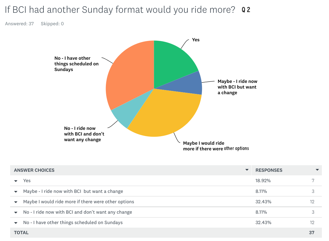
Below are the analysis of survey responses we received:

&gt;53% of respondents do not ride with BCI on Sunday

>53% of respondents do not ride with BCI on Sunday

&gt;59% say they might ride more with BCI on Sundays if there is a change

>59% say they might ride more with BCI on Sundays if there is a change

&gt;21% say they would welcome what we did - have Saturday rides on Sundays.  (Sorry - we don’t plan to offer free beer)

>21% say they would welcome what we did - have Saturday rides on Sundays.
(Sorry - we don’t plan to offer free beer)

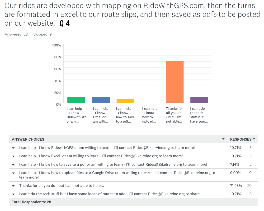
Only a few said they would help the Ride Coordinator with mapping rides, crafting spread sheet cue slips or posting pdf’s for the club… those who said they could help, and other willing - PLEASE do contact Paul @ Rides@BikeIrvine.org !

Only a few said they would help the Ride Coordinator with mapping rides, crafting spread sheet cue slips or posting pdf’s for the club… those who said they could help, and other willing - PLEASE do contact Paul @ Rides@BikeIrvine.org !

A wide collection of comments - including some nice ‘Kudos’.  Remember - it is your club so please take a turn at the front, helping support the Board, or run for a position next year. Rides need help reviewing errors before repeating so take the time to point out any you experience.  Members are always encouraged to suggest rides and routes, and we always need help generating and correcting routes. Picnics &amp; BBQs and meeting speakers and covid adjustments have taken a lot of volunteer work so please pitch in with a little help or take a leadership role. If you see others needing to be trained on legal riding or group etiquette, offer that concern when you see it.

A wide collection of comments - including some nice ‘Kudos’.
Remember - it is your club so please take a turn at the front, helping support the Board, or run for a position next year. Rides need help reviewing errors before repeating so take the time to point out any you experience. Members are always encouraged to suggest rides and routes, and we always need help generating and correcting routes. Picnics & BBQs and meeting speakers and covid adjustments have taken a lot of volunteer work so please pitch in with a little help or take a leadership role. If you see others needing to be trained on legal riding or group etiquette, offer that concern when you see it.

Thank you to the 37 members who took the time to give some feedback on the Sunday Rides.

Irvine Police URGE you to register your bicycles

The Irvine Police recover a lot of lost / stolen bicycles and can not find their rightful owners… Rather than trying to get everyone to get a “Bicycle License” and put an ugly sticker on your frame, the NEW system is to register on line and know that if stolen, then found, the police will use the same data base to get it back to you! Partnering with the well established Project 529 the Irvine Police has a portal to register your bikes at www.project529.com/irvine. Before you log on, get your bikes’ details and serial number(s) handy… and brand, model, color etc… You can also go directly to www.project529.com and create a “garage” for all of your bikes…
Below is IPD’s flyer with a code to open the Project529 app on your smart phone.

New-Normal Self-Serve Sign-In steps

New+Normal+Sign+In.png

Challenged getting signed in to a BCI ride?
Here are step-by-step instructions for CURRENT MEMBERS:

1: Log onto our TidyHQ site. Use your email address and personal password. bci.tidyhq.com Select the Bicycle Club of Irvine if not already taken there… (If you are an Admin, select “Public Page”) You will be shown the next 2 upcoming events on the Welcome page - click one you want to sign-in for if shown.

2: Click the word “Events” top & center. bci.tidyhq.com/public/schedule/events
This will show you all scheduled upcoming events you can sign in for…

3: Click any event you want to sign in for. There are 15 small images you can click on, or scroll down & click the [Attend] button for the event you want to sign in for.
Note - If the member Ticket says “ U N A V A I L A B L E “ you are already signed in

4: Click the [ Get Tickets ] button.

5: Click the (+) to add 1 Member ticket ( default is 0 ) it will then say “Limit reached’ as you can inly sign-in once. If it says “ U N A V A I L A B L E “ you are already signed in.

6: Click the [ Checkout ] button to confirm your ‘order’ and go to the Payment page.

7: Click the [ Submit order ] button to ‘buy’ your free ‘order’ and go to the Success page. You do NOT need to print or save a ticket. You will get an email Order confirmation.

We would rather have you signed in and not show, than have you ride without being signed-in, so if you wish, you can repeat this process for every available sign-in ticket we have published on one log in session, rather than doing it the night before or early before you decide to ride. Repeat steps 2 to 7 for each date. It may be helpful to note on a list what you have already signed in for so you don’t try twice for the same date…

For Guests (including expired BCI members):
If not able to log in, you will be asked the first time to create an account at BCI.TidyHQ.com with your email and a password you set. The steps will be the same as above, except you can only ‘buy’ Guest sign-in tickets, but you can buy more than one; giving names and emergency contacts for each guest riding.

If something goes wrong, please contact Bill ASAP to figure out & correct the problem !
Text 9433678 in the 714 to reach him immediately!

Tire tread Line Narrow.png

If you are a current member but do not have access to sign-in online,
print out
THIS FORM, fill in your name & print a stack, then date & sign it for each ride you attend with legible name & BCI#, and give it to the park staff, or slip it in the door at UCP or the mailbox at DCP if no staff on duty. Please turn it in to the leader on any remote ride / event.

If you are
expired or a guest, and do not have access to sign-in online,
print out
THIS FORM, complete & sign it & get it to staff or the remote event leader before you ride.

Bike Path Challenge !

For those of you riding on your own & looking for new places to go… Here is a challenge for you all:
See the following list of Class I off-street bike & shared-use paths across OC.
How many of them can you ride on during the rest of Bike Month and early October ?
Deadline is our General Meeting on October 14th - Start a check list & amaze us!

Check List as a printable pdf:

BONUS POINTS – Add any path you know of or find over ½ mile long!

Aliso Creek – Upper  (from Paseo Valencia to El Toro Rd just south of Cooks Corner)
https://ridewithgps.com/routes/34182019 8.5 miles 

Aliso Creek – Lower  (from Alicia Pkwy @ Awma to Laguna Hills Dr)
https://ridewithgps.com/routes/34181995 3.4 miles

Anaheim Coves (from Ball to Frontier)
https://ridewithgps.com/routes/34182062 2.5 miles

Beacon Hill Way (Chapparosa Park to Golden Lantern)
https://ridewithgps.com/routes/34182093 1.1 mile 

Bonita Canyon – North (Bonita Canyon @ MacArthur to Newport Hills Dr)
https://ridewithgps.com/routes/34182153 0.7mi

Bonita Canyon – South (Newport Hills Dr to San Miguel)
https://ridewithgps.com/routes/34182172 0.3 mi

Bonita Creek – East (SD Creek to Bonita Creek West)
https://ridewithgps.com/routes/34182180  0.8 mi

 Bonita Creek - West ( University to Bison)
https://ridewithgps.com/routes/34182188  0.8 mi

Borrego Trail (Alton @ Commerce Ctr to Baker Ranch Rd)
https://ridewithgps.com/routes/34182211  1.1 mi 

Bosque Trail (Great park Blvd to Irvine Blvd)
https://ridewithgps.com/routes/34182228   1.2 mi

Brea Dam (Brea Dam Park Hostel to St Jude’s)
https://ridewithgps.com/routes/34182242  0.4 mi

Brea Trail – West (Imperial to Birch)
https://ridewithgps.com/routes/34182280  2.1 miles 

Brea Trail –East (Birch to Surveyor Ave)
https://ridewithgps.com/routes/34182291  1.2 mi

Bren (Sunnyhill to Ridgeline)
https://ridewithgps.com/routes/34182307  0.5 mi

Como (From Peters Cny to Harvard)
https://ridewithgps.com/routes/34285144 0.3 mi

Coyote Creek – Lower (San Gabriel River to Foster)
https://ridewithgps.com/routes/34182348   9.5 miles

Coyote Creek – Upper (La Mirada Blvd in Buena Park to Imperial in La Habra)
https://ridewithgps.com/routes/34182370  2.8 miles 

Crystal Cove – West (Pelican Point to the Shake Shack)
https://ridewithgps.com/routes/34182380  1.5 mi 

Crystal Cove – East (The Shake Shack to Reef Point)
https://ridewithgps.com/routes/34182400 0.8 mi 

Cypress Village Trail (Sand Canyon SP to JOST)
https://ridewithgps.com/routes/34182411  1 mile

Edison Easement  (El Rancho Verde Park in Cypress to Turtle Park in Buena Park)
https://ridewithgps.com/routes/34182451  2.8 miles

El Cajon - West (Bastanchury to Grandview)
https://ridewithgps.com/routes/34182482  3.6 miles

El Cajon – East (Arroyo Cajon Dr to Fairlynn Blvd)
https://ridewithgps.com/routes/34182509  1.1 mile

Freeway Trail (From San Diego Creek to Sand Canyon)
https://ridewithgps.com/routes/34182529  4.2 miles 

Great Park (Marine way to Great park Blvd)
https://ridewithgps.com/routes/34182559  1.1 mile

Harbor View (from NB MacArthur to Bonita Canyon Tr - South)
https://ridewithgps.com/routes/34182573  0.3 mi 

Hicks Canyon (From Rattlesnake/East Peters Canyon Trail to Portola)
https://ridewithgps.com/routes/34182593   2.2 miles 

Huntington Beach (from Santa Ana River to Seapoint)
https://ridewithgps.com/routes/34182136 5.5 miles

Huntington Beach – Bolsa Chica Beach Path (Seapoint to Warner)
https://ridewithgps.com/routes/34182114 2.9 mi 

Jeffrey Open Space Trail (5 Freeway  to Portola)
https://ridewithgps.com/routes/34182604  2.4 miles 

Juanita Moe Trail (University Trail to Shady Canyon Trail)
https://ridewithgps.com/routes/34182612   1.1 mi

Live Oak Canyon (Antonio Pkwy to Avenida Empresa)
https://ridewithgps.com/routes/34182635    2.3 miles 

Pacific Electric (from South Susan @ Alton to West Chestnut)
https://ridewithgps.com/routes/34182055 5 miles

Peters Canyon – South  (from Bill Barber to Warner)
https://ridewithgps.com/routes/34182641   0.8 mi 

Peters Canyon – New (from Warner to Como Channel or Walnut Trail)
https://ridewithgps.com/routes/34182652   1.1 mile 

Peters Canyon – Middle (from Como to Bryan)
https://ridewithgps.com/routes/34182660   1.6 mile

Peters Canyon – West Irvine (From Bryan to Peters Canyon)
https://ridewithgps.com/routes/34182673   3.8 miles

Peters Canyon – North (from Peters Canyon to Santiago)
https://ridewithgps.com/routes/34182698   0.8 mi

Peters Canyon West Bank / Rattlesnake (from Bryan to Portola)
https://ridewithgps.com/routes/34182710    1.8 mile 

Tustin Branch - Esplanade Trail (Dirt - from Warren to Fairhaven)
https://ridewithgps.com/routes/34285130 1.5 mile

Modjeska Trail (From Portola Springs to Tomato Springs)
https://ridewithgps.com/routes/34182723   0.9 mi

Newport Dunes (from Bayside to Back Bay Dr)
https://ridewithgps.com/routes/34183090    0.7 miles 

Portola Side Path - West (from the 261 almost to Jeffrey)
https://ridewithgps.com/routes/34284947 1.6 mile

Portola Side Path - East (from Hicks Canyon near Jeffrey to the 241)
https://ridewithgps.com/routes/34284957 3.7 miles

Saint Jude’s (St Jude’s to Bastanchury)
https://ridewithgps.com/routes/34182746   0.3 mi

Salt Creek (From beach to Parc Vista )
https://ridewithgps.com/routes/34182780   3.9 miles 

Santa Ana River Trail (PCH to Green River)
https://ridewithgps.com/routes/34182850  30.6 miles 

Santiago Creek  (5 Freeway in Santa Ana to Cannon in Orange)
https://ridewithgps.com/routes/34182883   6.7 miles

San Diego Creek (From Upper Newport Bay to Bake)
https://ridewithgps.com/routes/34182906   11.5 miles

San Juan Creek (Trabuco Trail @ Descanso Park to Avenida Siega)
https://ridewithgps.com/routes/34182936   3.4 miles 

San Juan Creek – Lower (Doheney Beach to Trabuco Trail @ Descanso Park)
https://ridewithgps.com/routes/34182982  2.4 miles 

Sand Canyon Side Path (from Portola to Alton)
https://ridewithgps.com/routes/34285158 4.1 miles

Shady Canyon (from Quail Hill to Bommer Canyon)
https://ridewithgps.com/routes/34182947   2.8 miles 

Sulphur Creek (Laguna Niguel Regional Park to Crown Valley Park)
https://ridewithgps.com/routes/34182964  1.0 mile 

Trabuco Creek (San Juan Creek to Avenida de la Vista
https://ridewithgps.com/routes/34182998   0.9 mile

Turtlerock (Mason Regional Wilderness Park to Starcrest)
https://ridewithgps.com/routes/34183007   1.4 mile 

University / Sand Canyon Wash (Freeway Tr north of 405 to SD Creek west of Harvard
https://ridewithgps.com/routes/34183035  3.7 miles

Walnut (Harvard to Sand Canyon)
https://ridewithgps.com/routes/34285139 3.1 miles

Woodbridge Lakes (Yale to Yale)
https://ridewithgps.com/routes/34183052  1.9 miles