Extending Santiago Creek Bikeway

We have been waiting a long time for the connection of the Santiago Creek Bikeway from Santiago Oaks in Orange all the way to the SART (Santa Ana River Trail).
“NIMBYs” have been screaming against it, but very few voices of path users have been heard. Here is a call for action to tell our county leaders that we want the network of bikeways connected.

Hi Trail Enthusiasts,

Re: Extending the Santiago Creek Bike Trail – Send a Letter to the OC Public Works

It’s time to contact the Orange County Public Works and tell them to extend the Santiago Creek Bike Trail all the way to the Santa Ana River Trail. So far the local authorities are only hearing from those opposed to a trail extension.

To help you with this, we have attached the mailing address for Nardy Khan,  Deputy Director-OC Infrastructure Program, O.C. Public Works. We have also included the email addresses of several government officials who should receive a copy of your letter.

In addition, we have also attached several samples letters that will help you get started.

We can’t wait to see a copy of all of your letters. If you have any questions, just let us know.

Ron Newcomb rnewcomb@socal.rr.com 

September Tours in Italy ~ Spaces Available

One of our sponsors, Wandervogel, just announced that 3 spaces just came up on the September trips:
A single female room - share and a couple have cancelled and these tours, long filled, so now each have spaces to join.

 September 4-15 Alps to Italian Lake District, one double room now available.
https://wandervogelbicycletouring.com/climb-wine-and-dine/
SPACE FILLED - Maybe join them in 2024?

September 17-28, Alps to Venice, one share in a double open for one lady. 
https://wandervogelbicycletouring.com/lakes-vines-and-venice-september-17-28/
SPACE FILLED - Maybe join them in 2024?

is a BCI Sponsor…


How to cycle on Bake across the 405 freeway

We recently added Bake SB over the 405 on the Tuesday Ride #21 and the ride IS stressful…
We could avoid it, but the bridges at ICD and Lake Forest are just about as stressful...

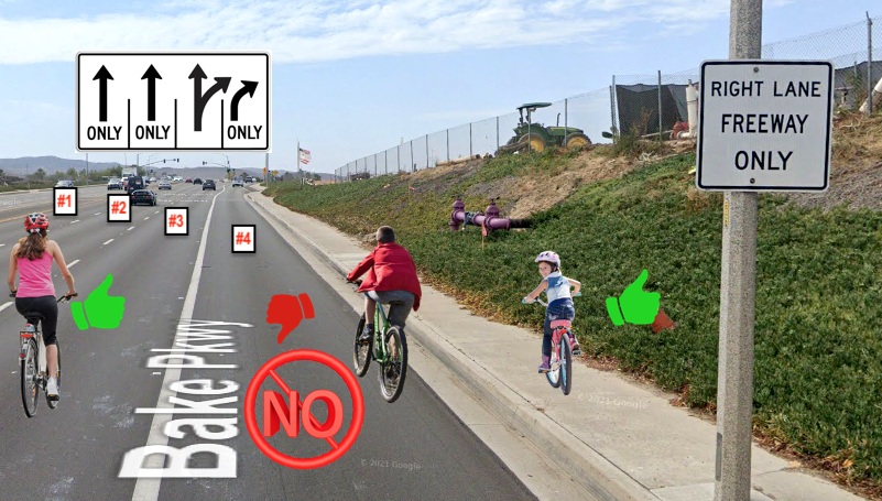
Even though Bake is a Class II bikeway, Irvine and Caltrans have failed to paint any of the Complete Streets tools, and allows both right lanes to enter the freeway at two high speed entrances. The route has been improved by taking Rockfield to Bake, reducing the stressful distance on Bake to 6/10th of a mile. These details explain techniques that can be applied at many of our high speed freeway entrances across OC.

Even though posted at 50 MPH, motorists speed on Bake, and they accelerate as they merge into the high speed entrances, making it critical for cyclists to assert their lane position early to be seen and safely cross the freeway.
You can’t signal and hope to be let over by aggressive speeding motorists , you need to time your merge and be assertive to control YOUR lane.

Rockfield to Bake: (@Mile 19.7 on T21)
• Pause on Rockfield to regroup; several cyclists together have an advantage to be seen and control any lane. Pausing also lets you time the signal so less traffic is coming down Bake behind you as you merge into the road.
• Merge out of the narrowing #4 lane as soon as possible to control the #3 lane.
There is no room to ride the gutter & share the #4 lane with passing vehicles.
Clear the #4 RTOL: take & Control the #3 lane or take the sidewalk.
If you don’t feel safe merging over, use a driveway to get onto the sidewalk.

Bake to 405 NB entrance:
• If you are already controlling the #3 lane, motorists heading for the freeway will pass on the right in the #4 RTOL. Those going straight can merge and pass you in the #1 or #2 lanes on your left.
• If you try to control the #4 RTOL you will have speeding motorist passing and entering the freeway across you from the #3 combo lane, and will be unable to merge over to control the #3 lane. Just stay right and use the shoulder.
• If you make it to the shoulder or ride the sidewalk, watch out at the crosswalk. If one lane stops for you the second lane may not.
Controlling the #3 combo lane really is safest.

BAKE to 405 SB entrance:
• There is an unmarked bike lane over the bridge, but merge back out to control the #3 combo lane as early as possible, well before the bike lane ends for a RTOL.
• If you make it to the shoulder after the bike lane ends or ride the sidewalk, watch out at the crosswalk. If one lane stops for you the second lane may not.
• Past the exit, everyone can use the bike lane toward Research, ICD, San Diego Creek, or Lake Forest…

AB 645 Speed Safety System Pilot for CA

Hello Bicycle Club of Irvine,


My name is Kristen Weiss and I am a policy and legislative intern for SAFE (Streets Are For Everyone), a non-profit organization that aims towards improving the quality of life for pedestrians, cyclists, and drivers in the Los Angeles community and throughout California.

I am writing to you to ask whether you can support an important upcoming bill, AB 645, that would greatly reduce traffic collisions in California through the use of speed cameras. As someone who is a Californian and a frequent cyclist, road safety is an issue that is greatly important to me as I have experienced numerous close encounters in which my safety has been at risk due to drivers speeding or not paying attention. Therefore, I believe this bill will improve road safety and reduce traffic collisions throughout California.

I hope your organization can support AB 645 which will make roads safer for everyone in California. I have provided more information about traffic collisions in Los Angeles, California, and AB 645 below; if you would like to know more about the issue and bill.

Los Angeles has seen a record number of traffic fatalities in 2022. See our report Dying on the Streets of Los Angeles, or you can watch our short video Something Must Be Done About Traffic Fatalities in LA. The biggest factor in the spike in serious injuries and fatalities is unchecked speeding. 

It’s not just Los Angeles. California had 4161 fatalities in 2021 and almost 20,000 people seriously injured.  The primary collision factor for traffic collisions in CA, speeding – 45.3% of all collisions were the result of unsafe speed. (Source: TIMS

Streets Are For Everyone (SAFE) is working with SF Walks, Streets for All and a coalition of other non-profits on an important piece of legislation this year, AB 645 -- Speed Safety System Pilot. Attached is a fact sheet on the bill, and the full language is contained here: AB 645 Full Language.

Whether it's from a traffic safety perspective, a social justice perspective, a public health perspective, or an environmental perspective, there are many reasons why this bill makes sense. We are working to build a coalition of support for this bill and hope you will be a part of this. 

How You Can Help
Sign on to the letter of support for AB 645. The deadline for sign-on is the end of business day on Tuesday, April 10th. 

Please look at the attached Fact Sheet and let me know if you have any questions. I'm more than happy to jump on a call to answer questions or set up a short presentation.

Thank you, in advance, for your support.


Best,

Kristen Weiss, Policy and Legislative Intern

Streets Are For Everyone


2023 MAMMOTH GRAN FONDO - Saturday, September 9, 2023

BCI Members #3632 & 3329 Kim and Peter Gerrard invite you to join them at the 
2023 MAMMOTH GRAN FONDO
https://mammothgranfondo.com/

Imagine: the beauty of nature, accented by the sweet scent of pine trees…with excellent rest stops and support, epic views, three amazing route options, free event photos, and a rad after-party!

Named a "Top-Ten Century" by Bicycling Magazine (June 2012) for its "Jaw-Dropping Vistas," the Mammoth Gran Fondo leaves the village of Mammoth Lakes and takes you along the spectacular eastern side of the High Sierra with awesome views of the Sierra Nevada Range, the White Mountains, and Mono Lake (for the longer riders). E-bikes are plentiful and welcome.

Routes:

Gran Fondo 102 miles
Medio 70 miles
Piccolo 42 miles
If you typically do BCI’s medium rides, you’ll probably want to do the Piccolo.


LOGISTICS

Register for the Ride: Register online by September 6, 2023. As of April, the price is around $119 and it goes up $10 every month, so register sooner rather than later. No refunds are permitted, but you can request a deferment. Read the registration policies.

Book a place to stay: Consider driving up on Thursday and staying overnight for at least 3 nights. We recommend staying at Mammoth Village Lodge. These condos are right at the start/finish lines and where the after-party will be. The units are typically condo-equipped and there’s a pool and a few outdoor jacuzzis.  If you stay elsewhere, you’ll  have to ride or drive your car to/from the event. All day parking is at least $15 bucks across the street. 

Getting to Mammoth Lakes from OC: The 325-mile drive from Orange County to Mammoth Lakes takes five to six hours, depending on travel conditions. 

High Altitude Acclimating: The town of Mammoth is at 7,881’. That’s why we’ll take an “acclimation” ride on Friday, Sept 8th. The trail winds through campgrounds, past stables, the Twin Falls overlook, and loops back at Horseshoe Lake. 

Contact: - BCI Secretary, Kim Gerrard - 949-294-4117 - secretary@BikeIrvine.org

Please send your name & best phone number, where you are staying & which days you will be there so we can all get in touch with one another.

PLEASE SIGN IN HERE TO SECURE YOUR MEMBER INSURANCE BENEFIT

If you have another event to share or coordinate with BCI Members, let us know!

Safety at Intersections

By Bill Sellin

Tustin Ranch Road in the City of Tustin is on several of our routes, and gives us many good examples - in quick succession - of when a Class II bikeway (bike lanes) has to deal with multi-lane traffic intersections.
If you are not aware of the reason experienced cyclists know to take a primary lane position and stay out of the gutter, see this explainer about why riding to the far right was changed for cycists back in 1963.


Riding north on Tustin Ranch there is a signal for the SB 5 freeway entrance and exit:
”Stop Bar” limit line and improperly painted bike lane across intersection.

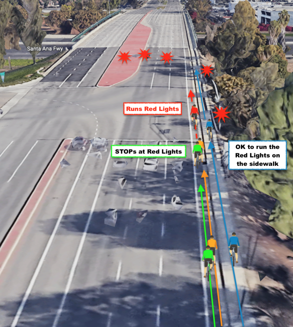
With up to 5 red lights and a clear “Stop Bar” limit line, club members still routinely roll through the red light and continue. Motorists exiting the freeway turning left into the NB lanes often swing wide. Running the red light when vehicles are swinging left works most of the time until it doesn’t. It doesn’t help that Caltrans and Tustin incorrectly painted the bike lane across the intersection as if it was a shoulder. The existence of the bike lane does not override the mandatory stop on red. Unless you are on the sidewalk…
Just obey the red light and stop in the bike lane.


The next intersection is the same, for the NB 5 freeway entrance and exit:
”Stop Bar” limit line and improperly painted bike lane across intersection.

Just obey the 4 or 5 red lights and stop in the bike lane.


The next intersection is at Auto Center Drive:
The bike lane is shared for turning motorists to turn from:

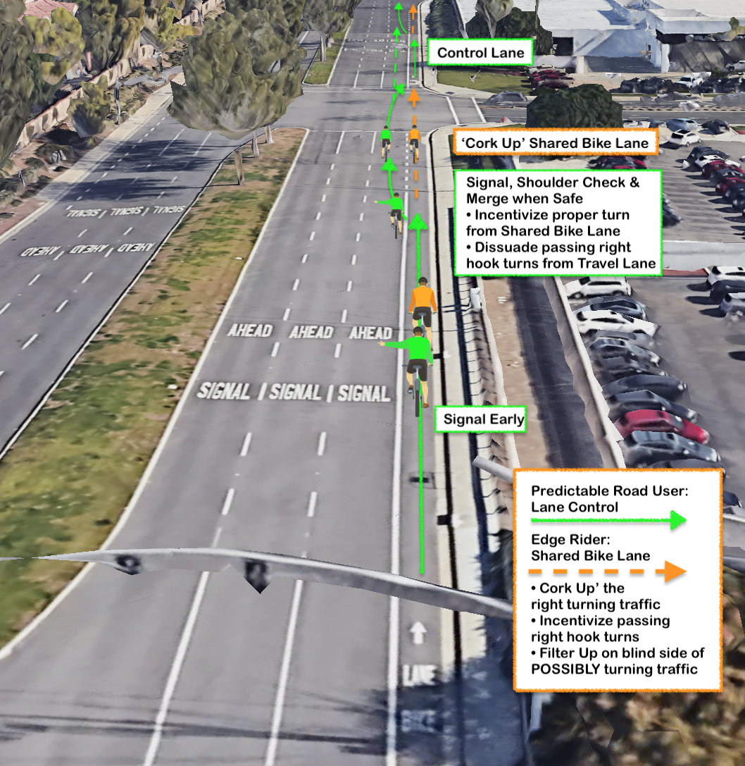
The “Detail 39a” standard is 4 foot dashes and 8 foot gaps, and can be painted from 200 to 50 feet before the intersection depending on speed and length of the block. This portion of the bike lane is SHARED with turning traffic. Motorist are legally REQUIRED to merge into ‘our’ bike lane to turn right from the right most lane. It is illegal to turn from the travel lane - because we cyclists may be there & can easily get right hooked, being in their blind spot. Motorists are supposed to merge in BEHIND us and if we ‘cork up’ the lane, must wait for us to move when the signal turns green.

Legally we MAY cork up the bike lane but for courtesy, traffic flow, and SAFETY, experts recommend leaving the bike lane clear for turning traffic.
If we signal early, check over our shoulder (don’t just trust or mirror) and merge out of the bike lane into the travel lane we do several things: We become much more ‘consequentially visible’ to traffic, and sooner, if we control the lane when clear; we dissuade motoris speeding passed us to make ‘right-hook’ turns across our path and incentivize them to do the proper thing and merge into the bike lane to turn right from. We also free up the bike lane for fellow cyclist who may want to turn right.
We frequently see motorists who do not know they are supposed to merge into the Bike Lane, who turn from the travel lane - often without even using a blinker. If we ride past on their right, especially at speed, we are taking a huge risk. “Filtering Up” on the right, in the blind spot of turning traffic that may suddenly ‘right-hook’ us, has killed many cyclists and can be completely avoided by US as cyclists: Never filter up on the right of traffic that may be turning across your path. At a red light, merge over early and take the travel lane with traffic to stay out of the shared portion of the bike lane. It is legal pass in the bike lane and to ‘cork up’ the bike lane but can be deadly. It is legal for cyclists to leave a “mandatory use” bike lane anywhere a vehicle may make a right turn for mitigation of this very hazard.
The City of Tustin has ‘dashed’ the bike lane marking it as SHARED for drivers to turn from. This is correct, but motorists do not know they are REQUIRED to merge in behind us, and frequently turn right from the travel lane. Cyclists do not know this and stay in the the bike lane, frustrating motorists and inviting them to pass and right hook us.


The next intersection is with El Camino Real:
The bike lane ends, has a weave-zone gap, and is extended left of the RTOL pocket

The City of Tustin has incorrectly ‘dashed’ the bike lane instead of keeping it solid up to the hip of the turn pocket as the MUTCD requires. We should have priority to the hip and not be sharing with vehicles before the pocket.
Tustin HAS painted the bike lane left of the RTOL (Right Turn Only Lane) pocket, but given the posted speed limit, it SHOULD be wider.
This should help make it clear to turning traffic that they should cross our path of travel and use the RTOL to turn from, and not turn right across our path from the #3 travel lane.
Tustin starts the RTOL less than the 100 feet from the end of the bike lane, as recommended by the MUTCD to give motorists a reasonable gap to merge across our path. That means some motorists will merge into our bike lane too early (because it is dashed) before the RTOL pocket, and others will cut across the extended Bike Lane to their RTOL pocket to late (because the gap is less than 100 feet). Expect both.
Tustin should do better, and could add the Complete Streets treatments to mark the conflict / weave zone for our safety, but has chosen not to. In Newport Beach, Santa Ana, Riverside, and many places that are implementing the current DOT Complete Streets standards, you will see the weave / conflict zone has been marked with green blocks to make it safer for us.
We should again signal early, check over our shoulder (don’t just trust our mirror) and merge out of the bike lane into the travel lane to reach the extension left of the RTOL pocket unless we are turning right. If we do it sooner rather than later, we are less likely to surprise traffic coming up fast… If we are a long group, and the extension is getting full, stop at the end of the bike lane to keep the weave zone clear and let turning traffic get to their RTOL pocket.
Again, It is a NARROW (sub standard) extension, so we tighten up so that we do not impede either the RTOL on our right or the through lane on our left.
Just stay in your lane.
When the light turns green, we can proceed with an assumption that the vehicles in the RTOL will turn turn and NOT come up on our right. Even so - look back on your right as you merge back over to the gutter-position bike lane across the intersection.

We may ignore a Right Turn Only Lane arrow ONLY IF there is
a Sharrow marking on the pavement and/or an EXCEPT Bicycle sign is posted


The next intersection is at Bryan:
The bike lane ends and there is a RTOL

Along the block after El Camino Real, the bike lane is dashed for the shopping center drive ways - and on approach to the RTOL at Bryan. (BTW: Irvine no longer breaks the bike lane stripe for driveways, only at intersections). The bike lane ends as a shared lane and we are REQUIRED to merge into the travel lane to proceed straight across Bryan, or REQUIRED to use the RTOL to turn east on Bryan. It is illegal to proceed straight from a RTOL UNLESS there is a EXCEPT BICYCLE sign posted or a sharrow marking added in the RTOL by each Right Turn arrow marking. The City of Tustin ignores Caltrans DOT standards and dashed our bike lane before ending it here. It should be solid up to the end and not shared.

We may ignore a Right Turn Only Lane arrow ONLY IF there is
a Sharrow marking on the pavement and/or an EXCEPT Bicycle sign is posted

Some try to squeeze along the stripe between the RTOL and through lane, but that invites unsafe passing on the left, and may succeed in ‘corking up’ the overly cautious traffic trying to turn right from their their RTOL. We SHOULD merge over and control our right-most through lane. Especially as a group. We should again signal early, check over our shoulder (don’t just trust our mirror) and merge out of the Bike Lane into the travel lane as soon as possible. If we can control the travel lane all the way from the signal at El Camino Real, we will not have to weave in and out of the shared bike lane at all, just hold our lane. Motorists will be able to choose the #1 or #2 travel lanes lanes to proceed straight past us up Tustin Ranch, or slow down and follow us in the #3 lane, or merge into the shared bike lane to turn into the shopping center or McDonalds, or to get to their RTOL for Bryan.

When BCI rides we see the riders all over the place - in all 3 arrows at the same time.
We look like a herd of cats and motorists, many who already don’t want us ‘in THEIR way’ get another example of cyclist being unpredictable. Add a kid on a moped driving on the sidewalk as we pass by and we really look bad to other road users and pedestrians.
Call out your fellow riders when you see them edge riding, filtering up along potential turning traffic, ‘corking up’ bike lanes or illegally blocking RTOLs.
BCI expects all of our riders to follow the CVC - and to know them as they pertain to cycling. See CVC Laws for Cyclists - 2021 update (review of California Vehicle Code)
If you think cycling is what you see on the Tour de France or racing, you do not belong on open roads with real life traffic.

If you have comments, please post them below - or reach out to Bill@BikeIrvine.org
Please learn as much as you can - you won’t know how much you DON’T KNOW until you start to learn more. Great Starts: See Cycling Savvy’s “You Lead The Dance” as copied by Orlando

Take the free online Essential short course to understand the many basic ways to be a safer cyclist: https://cyclingsavvy.org/courses/essentials-short-course/

Here is an excellent on-line tutorial explaining Lane Position & why we don't edge ride the gutter, especially in narrow lanes: Understanding Cyclists Position on the Roadway

See this great article on how increasing speed increases our risks and how to mitigate them, including why to take the lane & stay out of the gutter: High Speed Bicycling

Moab Trip - September 2023

BCI Member #3063 Maria Perkins invites you to join her excursion to Moab Utah on September 15-23.

This 6 day plan includes the sagged two day Moab Century that will cost each person $195. It is put on by Skinny Tires Events. Hotel and food (aside from what the Century provides) is on your own. Ten rooms are currently reserved at the Aarchways Inn for our group. Rooms with 2 queen beds start at *$189 per night for a total of $1134 (excl tax & fees) for 6 nights.*The Moab Century rate.

Register for the Moab Centugg: *To join this group, you will need to register for the Moab Century by 7/1/2023 or earlier. The price is not refundable. skinnytireevents.com/moab-century-tour

Stay: The Aarchway Inn is located at the start for each of these out and back rides. Each room has a microwave, refrig.,coffee pot. Included: internet & cell service, a free breakfast buffet, & a pool + Jacuzzi.

*Schedu|e: *Celebrate & compare plans for the next day at a 5 p.m. happy hour each night. BYOB....and any snacks to share. We'll meet before the October trip & Zoom too.

1) Friday Night: 9/15/2023 Arrive in Moab: Join the group at 5 p.m. for dinner.

2) Saturday, 9/16 Moab Century Day 1 - *63 miles, 3800 ft of climbing *(shorter or longer routes available two weeks before the event) ridewithgps.com/routes/30884120

3) Sunday, 9/17 Moab Metric Century Day 2 - 64 miles, 5K ft of climbing ridewithgps.com/routes/30884266

4) Monday: 9/18 Off (Hike or mountain bike, or?? Jacuzzi??- It's your choice.)

5) Tuesday: 9/19/2022: *Arches National Park Ride: 42 miles, 3870 ft of climbing. Sagged. ridewithgps.com/routes/26983435 *Maybe hike afterwards or hike instead?

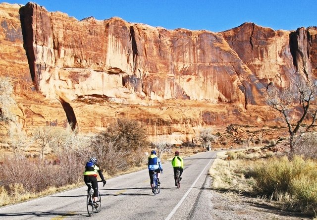
6) Wednesday, 9/20, River Portal Loop, Potash Rd: 38 miles, 1380 ft of climbing: See cliff walls that run along the Colorado River — Not sagged. ridewithgps.com/routes/29683436

7) Thursday: 9/21 Leave for home.

Ride Insurance for Tuesday & Wednesday Rides:
Sponsored by BOBies Cycling Club: (ButtsOnBikesInlandEmpire)
Join to receive insurance coverage for Tues. & Wed. rides only. Cost is $25 annually.

CONTACT: Maria Perkins — 909-319-2400 bper816@aol.com
for details and to get on the list.
You will receive a survey and we will zoom soon. Please provide your email address & phone number so we can add you to the MOAB 2023 WhatsApp group. *You will also be asked to sign Disclaimers and provide a Medical information Form.

CYCLING FRIENDS of MOAB 2023
”Ride and Eat” on April 2nd - Learn about the September Moab Trip - 3 ride option on Santiago Canyon rolling at 8, 8:30 and 9. Potluck (optional) & BYOB
RSVP with Maria by March 19 to get details.

BCI is now on Meetup

In an attempt to find more members, BCI has stated a pilot Meetup Group.
We will run it for 6 months and see how well it gets word out about our club; If you see more guests show up, take the time to welcome them, and as needed - explain why we ride the way we do…
Some may have some inexperience or bad habits we collectively can help improve!
If you are in Meetup, please join the group. If you are not involved in meetup, check it out - there are some very interesting groups hosting all kinds of activities near you that you might enjoy!
meetup.com/bicycle-club-of-irvine/

After a year of offering BCI as a Meetup Group, we have cancelled our subscription effective Dec 27 2023. We got about 100 prospective members but only a few showed up for any rides so it was not worth keeping the MeetUp Group going. Most find us from a simple search or word of mouth from friends or shops.

Venta Spur Bicycle/Pedestrian Bridge Ribbon Cutting

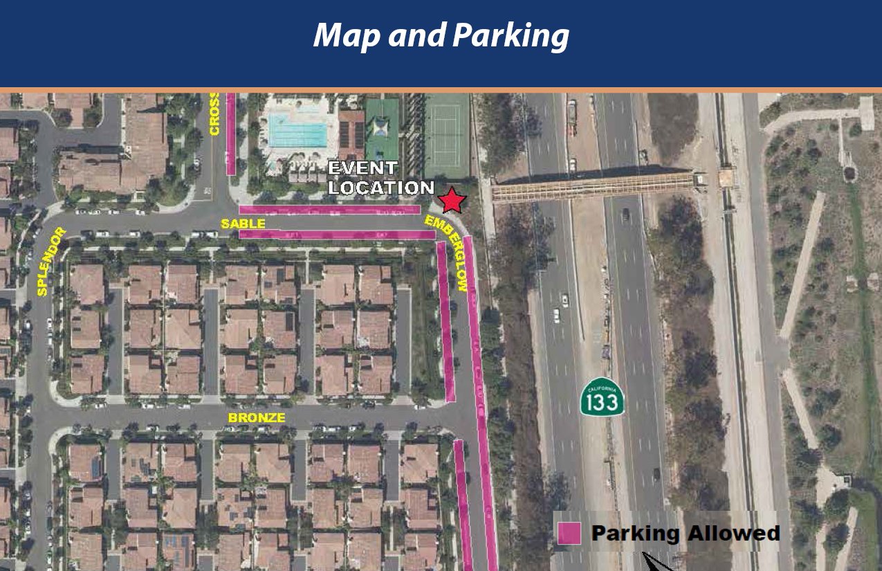
The City of Irvine has completed a bicycle - pedestrian bridge over the 133 toll road to connect the Great Park to Northwood. Please join us as the community celebrates with a ribbon cutting program. This new link will create a vehicle free connection across the 133 Toll Road between Trabuco/Great Park Blvd. and Irvine Blvd.

We would expect most BCI members to ride in on a bicycle...

Location: Corner of Sable & Emberglow https://goo.gl/maps/bKbQxZsdfLAEYm988

Climb Factors

So on yesterday’s ride Rick asked Bill if there was a hilly-ness rating we might use to rank routes… intrigued, as “flat” “rolly” and “hilly” was always subject to the interpretation of the ride coordinator, and what Norm called “flat” was not what everyone else experienced as flat.
Now that RWGPS gives us a +/- elevation change on every route we design, we can calculate the factor of elevation divided by the miles of the ride to come up with a “feet per mile” number we’ll call the “Climb Factor”.
Bill ran the numbers on the Tuesday Routes and found a range from less than 20 feet per mile to over 50 feet per mile: Tues14 & 18 are less than 20’/m; (Climb Factor 1)
01 & 13 25 are in the 20’s. (Climb Factor 2)
Most routes are 30’/m to 40’/m. (Climb Factor 3 & 4)
06 & 17 30 are over 50’/m. (Climb Factor 5)

Our Weekend Routes range from CF 0 (less than 10 ft per mile on DCP01 S with 109 feet in 18.2 miles) to CF 7 (over 70 feet per mile on DCP21 L+ at 4,594 feet in 59.7 miles!)
So when a Climb Factor is on a route, it can give you an idea of how much elevation you can expect, relative to the distance. (Probably TMI but maybe it will catch on!)

Since most rides start & end at the same location, the climb and descent are the same. Some rides - like Riverside down stream to Anaheim may have a Climb Factor in a negative number.
You can do your own calculation: If the route is 38.3 miles & elevation is shown as +/- 1,234 ft just do the math: 1,234 / 38.3 = 32.2’/m (feet per mile) so that would be a “Climb Factor 3”